I stopped at the Welcome Center rest stop just across the state line, but could not find the cache. But I did complete the questions about Michigan Rocks and got credit for a Earth Cache to get the Michigan souvenir. I arrived at the RV Park, which was all open and rows of RVs. Most were trailers with boats. I did not set up, I took off to find the geocaches on the beach,
which turned out to be a real long walk and I could not find either of the caches. No worries, there are three more on the bike trails, but I later found out that area was closed. I went in through the barricades but was run off by a guy on a earth mover.
When I got back to the van it was covered with these big mosquitoes looking fly which turned out to be Mayflies. They were really not a bother, they didn't bite, but there was so many. I put up the mosquito net across the door to keep them out of the van. I got them off all the bins I took out of the van and got everything inside. In the morning they were still there, but they were not alive. It's like they just dried up. I was up early and went and took a well needed shower, when I returned most if the dead ones had blown off replaced by new ones.
I spent the rest of my time planning my trip east through Ohio, Pennsylvania and New York.
I found a place on the Pennsylvania coast called Presque Isle State Park. There is a monument about the Naval battles in Lake Erie. I Had a good time taking the walk getting all the answers to the Virtual cache questions about Capt. Oliver Hazard Perry.
Not knowing how far I was going to drive, I continued east into New York through Buffalo andI plan to stay the night for free at a rest stop or another Crackle Barrel. The first "Service Station" , not really a rest stop, there is a gas station and a Dunkin Donuts but there was a sign saying no overnight parking 4 hour limit. So I headed down the road and found another one. This one was partly under construction, but there was no sign so I decided to stay and see if someone tells me to leave. Soon there was another Van, a truck and camper and semis parked for the night.
The next day I decided not to pay the turnpike tolls and take the scenic route through the Finger Lakes. I stopped at Canandaigua Lake, Seneca Lake and Skaneateles Lake. Passing Farms and small towns, just enjoying the drive. Before I new it I was pulling into Glimmer Glass State Park (Otsego Lake) - Cooperstown, NY.
I cached my way through Kentucky, stopping in small towns and earning a new souvenirs. Northwest into Indiana briefly then arriving late into the Miami Whitewater Forest Campground north of Cincinnati OH.
Campground was crowded, being the weekend and the sites, a mix of tents, truck campers and RVs were close to one another. Still it was a nice park with plenty to do and they had geocaches in the park. I was up early in the morning and went on a wonderful rainy hike and found 3 Ohio caches.
After my coffee, I took off heading into Indiana quickly finding my first cache and then on to a nice graveyard virtual cache about Vivian's Doll house, Sad but well done. It was in small town Connersville IN. To get credit for the cache you have to name at lease one thing inside the doll house. I answered; Coal/wood stove, Tricycle and wagon with Vivian on the side, Bed, Chest/trunk, Baby doll and lady doll, Portrait and Tea set.
I continued on north back into Ohio en route the shores of Lake Erie in Michigan.
Heading north through North Carolina and Virginia, on course for the Virtual Cache HBC..Who? just over the border where the 77 freeway ends near Bluefield WV. After driving all day I had a nice walk around the campus of BLUEFIELD STATE TEACHERS COLLEGE which earned me the West Virginia Souvenir. Todays camp is Panther State Forest, a remote location some 60 miles in back country road that winds through coal mining communities.
"Take me home country roads" Narrow tree covered, sometimes only one car wide roads along rivers and creeks where in some places the asphalt has been washed away. I finally arrived and check in with Ranger Sam at the camp office. Sam proceeded to had me a pile of magazines, brochures and flyers, oh and a map. He said he would bring some fire wood up when he closes the office. The campground the was just a row of about 7 sites just off the road nestled on Panther Creek. I got set up and Sam stopped by with the wood. It was very peaceful with the sound of running water and thousands , millions of Cicadas.
After I ate dinner, grilled chicken with salad, the sun fully set, the fire flies came out. Hundereds of them dancing through the air, it was quite the show. Just as I was wishing I was staying more than 1 night, the rain started and it was a down pour!
It rained all night through the morning. Having no internet, I packed up and headed to the camp office. I wanted to see if the rain would stop long enough to hike the overlook trail. But Wifi was down and the ranger on duty said the rain will last all day. So I headed back out the way I came in until I got a cell signal and mapped directions to Pikeville Kentucky to earn my next state souvenir. 👀photos
I had an uneventful drive from Alabama to South Carolina "In my mind I'm going to Carolina ....." -JT a state I have never been before. I was able to get the State Souvenir at the South Carolina Welcome Center Rest Stop in Fair Play SC. Only 12 more states to go! The campground was not very full, and the ranger station was closed when I arrived. There was nice tree cover at my site that let in just enough sun light and break the wind, which was picking up.
The light rain turned into a down pour over night and it was rainy for the rest of my stay. Everything got wet, but I figured I need this in preparation for camping in Washington later this summer. So I went on with my adventures. I was up early the next morning, broke camp to go get a North Carolina cache. I was real close to the border, so I looped around and pulled into the North Carolina I-85 Welcome Center Rest Stop and earned the NC State Souvenir! Returned to the campground and checked in to the office. After getting set up again, I pulled out my NW rain gear and set off for a bike ride to the
Kings Mountain National Military Park, about 3 miles down the road. The virtual cache at the park, called Furgeson's Folly, has you take the 1.5 mile walk around the battle site and answer 8 questions about the battle between Patriot Forces commanded by Col. William Campbell and the British Forces, commanded by Patrick Furgeson who fell in the battle. Ever wonder if Furgeson had won?
I returned to camp and hunkered down in RAMVAN. The rain continued until the next morning when I set off for West Virginia. Until then, I leave you with a link to photos of Kings Mountain.
Moochdocked at Carla's for 2 days. I was able put a dent in the local cache population, catch up on Laundry and spend time with my daughter and her special someone!
Thanks for cooking me a hot meal and the father's day card. 💛
I left Veterans Park, 4363’ elevation , head up the west side of the continental divide and down the east side on route to Monahans TX elevation. 2729’ Funny to think of it that way.
I arrived at the Sandhills State Park just before the Park Office closed for the day at 1630. Ranger Phil checked me in and said he was a AK (procures, receives and issues supplies, materials, parts and equipment for Navy Aviation) in the Navy for 5 years. We swapped a couple sea stories and he gave me a free park sticker. It was free because the S is missing from Monahans, so they can't sale it. As he was locking up, he told me about the Geocache in the park. As soon as I found my space and parked, I took off on the Jaguarundi 🚲 in search of the cache which ended up a 1000' walk up and down the sand hills, like a beach! I continued to ride just outside the park to find another one. I had to wait for the office to open up in the morning to get the answers for the Earth Cache.
I got back to the van and got set up. I have been using traction boards to level up the van. I cooked dinner and watch the Padres game. The day use area had groups of kids using saucers to slide down the sand dunes. I had fun watching them as the sun set. My space pointed north, so in the morning I had a good view the sunrise. I stopped at the park office on my way out to get the answers to the Earth Cache. Talked Geocaching with the Rangers and got on the road heading east.
I found this place on 12/23/24 on my way home from Alabama. There is a cache in the tank at the entrance. Easy access just pull into the end spot with table canopy and grill. Flat hard packed dirt/ gravel very level. Only two other campers here. There are no amenities, I did see a water spigot but it might be for irrigation. I took off for a walk in the open fields across the street. More campers arrived later when I was cooking my dinner, but the place was far from crowded. Nice peaceful over night. Veteran's Park photos
052925 I had a notion to travel every summer to get out of the heat in Sun City May - Sept. In May I spent 22 nights in the GeoVan, Today, I am starting a trip to find a cache in all U.S. 50 states,
I have 13 left: 1 South Carolina, 2 North Carolina, 3 West Virginia, 4 Kentucky, 5 Ohio,6 Indiana, 7 Michigan, 8 Massachusetts, 9 Connecticut, 10 Rhode Island, 11 Vermont, 12 New Hampshire, 13 Maine. My plan puts me in Maine on 6/15/25 and between Michigan and Connecticut, I'll visit the Baseball Hall of Fame.
Once I get to Maine, I am pretty sure I will visit Canadian Provence's: New Brunswick, Nova Scotia, Prince Edwards Island, Quebec and Ontario. I will see how I feel once I get to the Ottawa area, continue across Canada or back into Michigan and take route 66 towards home. Here is the link to my google map
After playing baseball, a little geocaching and a long game of Battleship with Sawyer, I decided just to stay there. Now I could have stayed in the house, but this was my first time camping on the street. Lisa also had me scared telling me how her truck was stolen ( I hope you get it back in good shape). I had an uneventful nights stay. Everybody had school or work in the morning so I took off to Lake Murray for a nice walk, after topping off my water tank ( thanks you very much). The Osprey was at their perch
I enjoyed my stay at this small park. At first I was taken back with the noise and the number of people nearby, but soon I found it was nice to have neighbors and hear them having such a great time. Most of all I enjoyed getting picked up and having a great time with Riley (and her parents).
Visiting the area to attend my Granddaughter's 8th birthday party. The sites are pretty close together and there is a trail going through the center of the park, connecting the sites, so you can expect frequent food traffic through the sites. This would make a good Boy or Girl Scout campout. Most of the campers were tenting but there was a few other small vans, truck campers and class C. Plenty of nature, but not a place to get away from the hustle bustle. What I liked most was the easy in and out while I went visiting. The gate is kept open, even though they may look closed after 8pm. If you have to go through late, use the exit gate.
I did take time to walk the lake and the numerous trails. This is a popular area on the weekends and the campground is only open Friday and Saturday nights. The restrooms were kept clean and the showers worked great.
Arriving right at 1400 on Tuesday May 13, cold and windy, I didn't need any directions finding the campground. There was one other camper and a group of tents down by the lake shore. The office was closed with a note to take to take my space and return in the morning. I parked, but did not set up. Instead I notices there was 2 new, well new to me, geocaches so I put on my warm coat and took a walk. Not much has changed with the lake,
soon I was walking by the bank where fishing with my kids, early 90's, they caught their limit and we had a nice fish fry. I remember I didn't fish because I was to busy taking fish off their lines and getting hooks back in the water, what a nice memory. Continuing around the east side of the island and across the bridge I proceeded to find the small hides. By the time I got back the westerly blow had eased to a moderate wind, so I re-parked and finished setting up. Dinner was grilled chicken salad.
The next morning I took off on the bike around the lake to check in at the tackle shop, complete an Adventure Lab and go after some more caches. Even though it was still cold and windy, the sun came out and turned out to be a beautiful morning. The Anglers I talked to said the trout were not biting, but they did get an occasional catfish. The clouds and wind returned in the afternoon, I hunkered down inside and took a nap.
Thursday morning I left the campground in the morning and parked on the south end of the lake. I rode up the jeep trails going after some more new hides. The last time I was in this area was March 2013 with Dan & Lisa we hiked up the Middle Peak trail. It still showed the devistation from the Cedar Fire, the largest of the 15 fires, began on October 25 2003 when a hiker lost in Cleveland National Forest sparked a fire in a desperate attempt to be rescued. In just 14 hours, what started as a relatively small blaze quickly swelled into a 28-mile-long conflagration, driven by the destructive power of the seasonal Santa Ana winds, and crossed into Cuyamaca Rancho State Park. Today there is much new growth, very green with spring flowers, parts of the trail are over grown. (https://www.americanforests.org/article/regrowing-a-forest/)
I stopped on the trail looking for a geocache and I heard this screeching. Looked all over for some kind of creature. Then when I was signing the log, I heard it again - like right in front of me. That’s when I saw the Bald Eagle. Stayed there for a long time, the Eagle giving me the eagle eye. Finally it took off to another tree top 🦅 N 32 59.192 W 116 34.229
050625 Badger Creek Dispersed Camping - Marble Canyon, Grand Canyon National Park. 36°46'35.2"N 111°39'33.0"W
I left the Flagstaff mountains, heading north towards Page AZ. My first stop was Valentine's Bridge at Tanner's Crossing, now called Cameron. Over a gorge of the Little Colorado on the edge of Navajo and Hopi country a sway-back, one-track suspension bridge was erected in 1911.
Continuing north on hwy 89 I headed to Horseshoe Bend. I have passed this so many times and never stopped. The parking lot was nearly full, cars, RV's and tour buses! $10 entrance fee just before the 2.4 kilometer round trip walk down to the viewing area. Even though I was turned off by the crowd, I enjoyed the walk and the views. Here is the Earth Cache Questions and my answers 1. Why did the Colorado River make this 270 degree horseshoe shape? The materials being eroded were softer than the point in middle, maybe more granite verses more porous sandstone. 2. What do you think horseshoe bend will look like 5 million years from now?All things equal, the river will go dry. But 5million years any number of geological events could take place. 3. How many millions of years did it take sand dunes to become petrified by the calcite, retaining their beautiful sloping dune shapes? 20 million or so <-- I googled this
4. The different colors, except for white, are caused by the presence of varying mixtures and amounts of what filling the pore space within the quartz sand comprising the Navajo Sandstone. Minerals that are impacted by the environment such as iron particles
5. Describe in your own words what you are seeing and experiencing as you visit Horseshoe Bend. Wow there was a lot of people but glad to see high interest. What I am thinking is this is a standard piece of science on a really large scale.
Next I headed back south to the Historic Navajo Bridge, which was the first bridge over the Colorado River for 600 miles. When the historic Navajo Bridge opened on January 12, 1929, Flagstaff's newspaper, the Coconino Sun, called it "the biggest news in southwest history." (https://www.geocaching.com/geocache/GC8209_historic-navajo-bridge)
I took a nice stroll across the bridge enjoying the views. I really like visiting historic bridges and taking photos of the engineering.
Arch 616', Total length 834' Height 467'
Now that I have entered the Marble Canyon area, it's time to find a place to set up camp. I used a app call Campendium to find Badger Creek Dispersed Camping BLM (Bureau of Land Management) public land. This particular spot started with a rough entrance off hwy 89A, but the van handled it very well, but a few things fell off the shelf. I went in about a mile, well away from the fifth wheel I passed and pull off into a camp site - right into some loose sand.
With tires spinning I got popped back on the rocky road. So I got out and found some hard packed dirt, parked and got the Jagrundi out and peddled farther in to see how the road is. Although it the road had some ruts and exposed boulders, it looked passable. In fact the next occupied campsite was a low clearance minivan. But I kept riding all the way to
the canyon edge, 2 miles from the main road. The last campsite had room for a large group and it lies right on the canyon edge. That's when it started raining. By the time I got back to the van I was all wet. Reloaded the bike and waiting for the rain the stop. Pretty soon I made my way to a nice campsite a little farther in. It kept raining off and on. I could see the rain clouds coming in over the cliffs. I counted 4 other campers during my bike ride, but as sunset neared four more came up the road, 2 vans, a pickup and a 4runner.
There was plenty of room between campers.
The clouds stayed all night, so there was no star gazing.
I had a good meal and read my book.
The wind picked up so I took my awning down.
No rain in the morning and it was an easy 65°
I really wanted to stay another day, but I had a Van upgrade appointment the next day so I had to make my way home.
Before I left the area, I went on a long bike ride hunting a couple geocaches on another jeep trail that ended with a 450' drop to the Colorado river. After that I stopped at the Cliff Dwellers stone house for a Virtual Cache. After posting my log, I took off back the way I came and visited Lees Ferry, Glen Canyon, $30 entrance fee, this is where they start a lot of the river rafting. Beautiful cliff views and I visited the old dwellings of the Mormon settlers. I took my time, parked by the river and had some lunch. Eventually, I made my way back through the Navajo settlements, Flagstaff, Sedona and into the Phoenix valley, getting home about 1900. Arizona has such a diverse land scape reachable within hours. Desert, mountains, cliffs and cactus forests. Here is the link to my iCloud album for this trip: Badger Creek Dispersed camping


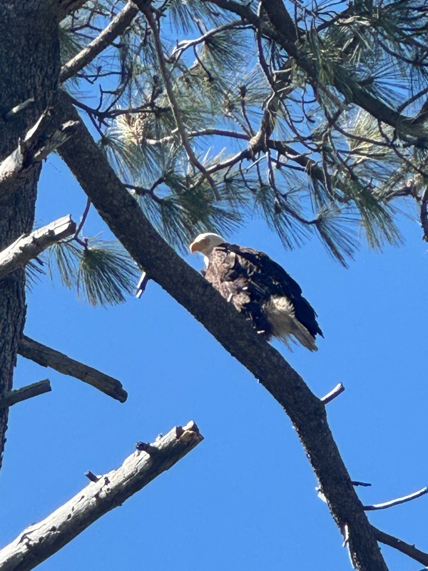
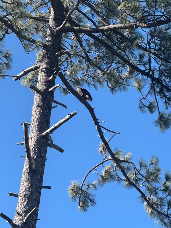 I stopped on the trail looking for a geocache and I heard this screeching. Looked all over for some kind of creature. Then when I was signing the log, I heard it again - like right in front of me. That’s when I saw the Bald Eagle. Stayed there for a long time, the Eagle giving me the eagle eye. Finally it took off to another tree top 🦅 N 32 59.192 W 116 34.229


