Showing posts with label National Monument. Show all posts

Thursday, July 2, 2026

Williams, Gooseneck, Arches


Arches National Monument

06282026 - 07012026 After spending 12 days recovering from the Colorado Crud, missing a visit to San Diego and an Old Time music camp, it was time for me to hit the road again. During the 12 days, I took care of some van maintenance items; New Tires, repaired a broken gray tank valve and raised the 12V refrigerator. I decided to start with an overnight closer to home in Williams AZ, just in case I had lingering symptoms  and to shake down the changes I made.

Williams, AZ
I found a nice spot at Garland Prairie Road Dispersed Camping near the south rim of the Grand Canyon. When I left Sun City about noon it was well over 100°F. 2 1/2 hours later I was setting up camp in 75° and sunshine.  There was still plenty of time left to go get some caches and enjoy a nice hike through the 6852' park. I found 3 caches that included a nice ammo box traditional that was in honor of a grave stone. 

Completely satisfied with my refrigerator reinstallation, I set off early in the morning west to Flagstaff then north through the Navajo reservation. 

When I first planned this trip, I automatically scheduled to stay at Sunset View campground at the Navajo National Monument, but it is barely 3 hours away and I wanted to get a little more miles in, so I continued north into Southern Utah 

Gooseneck - San Juan River
Just across the state line I stopped and logged a virtual cache called Harry and Mike's Place near the Goulding Lodge. I drove through Monument Valley on the highway that is in the movie Forest Gump, the scene where he stops running. 

I was not sure what to expect when I arrived at the Gooseneck State Park campground  hoping that there was an open campsite. There were probably 8 designated sites and I was only the second camper there. There was a steady stream of visitors throughout the day because the view of the Gooseneck canyon was breathtaking and I was camped right on the edge of the canyon. The San Juan River twists and turns through sinuous 'goosenecks' as it flows toward Lake Powell traveling over 6 miles while it advances to the west only 1 mile.  Well worth going off the beaten path to see the 1,000 feet between the overlook and the river, 300 million years of geology is revealed in the layers exposed by erosion. (GC5H9T9)

I got set up and took a long walk to get the two regular caches near the canyon. There was also a EarthCache and a Virtual cache at the visitor's overlook. So 4 smileys and a $10 campsite, throw in a beautiful sunset and a more exciting moon rise. Life is good. 

I stayed up late watching the sky, using some of the things I learned at RMSS, and tried to capture a photo of the red moon rising.  In the morning, I wanted to get an early start, but it was hard to stop staring at the views. I was able to get everything ready before 10am, but the van would not start!  I mean it was like the battery was dead. Fortunately, I have a VIKING 1000 Peak Amp Multifunction Jump Starter and Power Pack with 150 PSI Air Compressor.  I had to google how to jump start the van, because the battery is under the driver floorboard. After several minutes of purposely keeping calm, I was able to jump start. I got my multimeter out and verified it was charging and let it run for about 30 minutes. It started right up after that. I must have left something on that drained the power overnight, I don't know. I'll keep an eye on it. I set my GPS to Arches National Monument, 2 1/2 hours away and headed out of the Gooseneck. 

South Window - Arches National Monument

After a quick stop at the visitors center, I decided on the Windows arch hike. I spent about 3 1/2 hours at the park and barely scratched the surface of all there is to see. The hike was pleasant but the air quality was bad due to fires to the west.  Still there was plenty of activity on the trails and viewing areas.  The parking lots were crowded but not full which made for a very fun and quick visit. Centrally located in Utah, I'm sure I will have the opportunity to return during my future trips.  I pulled into Green River State Campground just before 1700, where I can dump my gray tank and get in a shower. I monitored my startup battery all day and it started fine the next morning. I thought about getting it tested, but it seems to be working normally.  Next stop Spirit Lake for the 4th of July weekend. 

Here is my Photo Stream thanks for visiting. 


Monday, June 15, 2026

Rocky Mountain Star Stare (RMSS) 2026


Messier 13 (M13) Globular Cluster

060926 - 061426 Rocky Mountain Star Stare (RMSS) is an annual star party sponsored by the Colorado Springs Astronomical Society that is held every summer for 30 years. So how di I hear about it, you ask? Well, on the Built-to-Go podcast of course! Hosted by Jeff Wagg of the College of Curiosity. Jeff’s weekly podcast features everything and anything about van life including events and places to visit. Jeff is a member of the Colorado Springs Astronomical Society and told everyone about the RMSS during one of his episodes. So I signed up months in advance and it is finally here. I really didn’t know what to expect other than I knew there would be camping in a big open area and I would meet Jeff Wagg. 

Jeff Wagg
After leaving Yucca State Campground I stopped at Loves to fill my propane tank, then headed up to the coordinates provided by RMSS. I recognized Jeff as I was pulling into the registration building and he directed me to where the Van Life followers were parking. Figured out later that it was the members area. I was honored to set up right behind Jeff's truck camper. 

There was nothing on the agenda the first day. I met all of Jeff's friends and the other Van Lifers that follow the Built-to-go podcast. We had hotdogs & drinks over with Yogi’s then later, around sunset one of the CSAS members, Bruce Bookout, conducted a opening presentation and someone set up a big telescope and showed us the moons of Jupiter! I was amazed and soaked in the presentation. We learned about the anti-solar on the east horizon; Earth's shadow / the "dark segment" and the "Belt of Venus".   Scientists explain this as the Earth's actual shadow projected onto our atmosphere. Over the years there have been folk lore and symbolism such as, the soft, glowing pink arc separating the dark night from the bright sky was likened by astronomers to this legendary ribbon of grace wrapped elegantly across the horizon and The Magic Cestus: The name directly alludes to the Cestus (a beautifully embroidered girdle, sash, or breast-band) worn by Aphrodite, the Greek goddess of love and beauty.  

As the sun set, the Astrometers worked on setting up their equipment in designated areas in the middle of all the campers. A strict "Red Lights Only" policy went into effect at Sunset. No other lights allowed to preserve the night sky viewing. 

I volunteered at the greeting table and directed campers arriving on Friday and Saturday. I find that volunteering is a good way to meet other people and for newbies like me to ask a lot of questions.  Friday night I spent 3 hours with 2 members that I was on watch with. They showed me their smart telescopes and we set them up with a tablet and zoomed in on some star clusters far away. The first image on this blog is one we took that night. 

Our group would usually meet in the evening at the observing area after dark and discuss the stars, sky and anything else there was to discuss.  There were presentations by people from NASA about Catching Astronauts, Recovery of the Crew of Artemis II and their Polarimeter to Unify the Corona and Heliosphere (PUNCH) Mission. There was other presentations including Mystery and Majesty in the Northern Skies. There was always something going on at the main building, which was the only building. 

The weather was fabulous until Saturday, we had some clouds, heavy winds and some light rain. Sunday morning Jeff was gone early but left a nice note on the discord. I was packed up and out by 1000. I stopped to dump my gray tank at the state campground then headed west through southern Colorado. 

Chimney Rock
I stayed at Ute Campground near Chimney Rock National Monument that I visited in the morning before heading out of Colorado. 

Just before entering Arizona I stopped at the Yucca House National Monument a  unexcavated archaeological site, based around an ancestral Puebloan settlement. The site was on a farm over by an old barn with a circle driveway. There was a walkway and trail that takes you right up to the ruins, an old brick-like wall that was first written about in 1878 then was made a National Monument in 1919. Read more about Pueblo settlements here. 

I stayed the night at the Sunset View Campground at the Navajo National Monument. Feeling kind of crummy, like I had a cold, I just stayed in the van and headed home the next morning, ending my 46 day trip. Total Miles 6856.7 average speed 47 mph, 17.8 mpg, Travel Time 145 hours

RMSS Photos

Ute CG Colorado photos


Wednesday, June 10, 2026

Toadstool Geologic Park

​


060626 Toadstool Geologic Park is noted for its unusual geological formations, some in the shape of toadstools, and scientifically valuable fossil deposits. Located northwest corner of Nebraska.  I heard about it as a place to visit on the Built to go podcast, so I put it on my list for on my way west. The campground consists of 12 sites with picnic tables, fire rings, upright grills and two accessible vault toilets. There is no water. There were three tent campers already there when I arrived. I parked and took the campground loop trail that featured information from a very informative Earthcache GC2CHP2. The weather was cooler in the afternoon, I was ready for a nice peaceful evening sitting at the picnic table with my salad and grilled ham & cheese with tasty Hungarian peppers. 


That's when a gust of wind blew my cap off. I looked up from my meal to see a dark sky beyond the foot hills, thunderstorm to the southwest.  I looked at the weather app which showed the rain starting a 2100.

After the sun went down, I sat outside to watch the lightning and take some pictures.  It was quite the show as the storm looked like it would pass to the west. At about 2015, I went inside and cleanup my dinner mess and put on an audiobook. 


The rain started right at 2100 and the wind was rocking the van. I was just thinking about hitting the sack when I received a weather alert on my phone. There was a link to a Nebraska Special Weather Statement that warned wind gusts up to 50 mph and penny sized hail. I stepped outside to determine the wind direction in case I need to move the van, thinking I would be ok with 50 mph head on but not broadside. The wind was coming right at my port side and the other campers were gone! I packed up and got out of the area. I ended up in Crawford NE, about 20 miles southeast. I found a place to camp at the city park. Crawford City Park Campground. 


I probably would have been fine if I stayed at Toadstool. I guess I will never know. Crawford was peaceful and there was no wind to speak of. I may have over reacted but I live to camp another day. 

πŸ‘€πŸ‘€πŸ‘€πŸ‘€Here a link to the rest of the photos.  πŸ‘€πŸ‘€πŸ‘€πŸ‘€πŸ‘€


Thanks for visiting. 


Monday, June 8, 2026

Carhedge and Agate Fossle Beds


6-6-26 Created by Jim Reinders Carhedge, located in  Alliance NE, is a replica of the famous Stonehenge in England. I arrived at 0930 and found the geocache in the parking lot then walked around the exhibit. There was another geocache in the exhibit. The log is an old station wagon near the far end of the grounds which is covered with signatures as it was placed in 2003. Very unique roadside attraction I stopped at on my was north from Scott’s Bluff. There is a nice trail and a gift shop. 


Next, I stopped at Agate Fossil Beds National Monument Visitor Center and Museum in Sioux County NE. I spent some time inside looking at all the artifacts on display and watching a film about the fossil beds and the people that discovered them. Afterwards I hiked the Daemonelix trail. Half way up the cliff face they discovered a series of vertical spiral shapes. The locals called them Devil Corkscrews but they are actually burrows of ancient beavers leading down to nesting areas underground. They are approximately 20 to 23 million years old, dating back to the Miocene epoch of the Neogene period. I completed 3 Earthcaches before continuing on north to the Toadstool Geological Park, which I will tell you about in my next post. 

Thanks for visiting 


Saturday, June 6, 2026

Chimney Rock and Scott’s Bluff NE

​60326 After getting an oil change it Wichita, I proceeded north towards the state border with Nebraska. I stayed at another Army Corps of Engineers campground called Methodist Cove Campground in the city of Alma NE. This puts a new state sticker on my water bottle. They have showers, coin laundry and dump station. I spent the next day bike riding a nice trail into town, I found the only cache along the trail and went to the bank to get quarters for the laundry. Had to ride through a flock of sheep! 

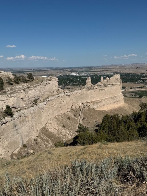
I left the next day driving west past Chimney Rock and into Scott’s Bluff. This was a pleasant surprise. I never heard of this place before and I was surprised how such a significant landmark would be so unpopular. This was(is) the real gateway to the west. Maybe because it’s named after an unfortunate fur trapper, Hiram Scot, who died there at the base of the pass in 1828 and not for some famous politician. There is a visitor center and a driving self tour of the north side of the landmark. Layers of sandstone, volcanic rock and limestone concentrations are exposed after years of erosion, telling the geological story in the area. I found it well worth the visit and took my time enjoying the scenery. 


It was late in the afternoon when I pulled into a non hookup space at the Riverside Campground in the town of Scottsbluff NE. 


Photos  


Wednesday, June 3, 2026

Arkanas, Missouri, Kansas 26


Norfork Lake Henderson Ozarks AR

I headed west after completing the Stone River cache and drove all the way to Arkansas. I have never camped in Arkansas so I will get another sticker on my bottle. My first night in "The Natural State" I stayed for free at the Blytheville AR Welcome Center  of Highway 55, very RV friendly and I was greeted with a beautiful rainbow! 

Welcome to Arkansas


This rest stop afforded easy access to Krogers groceries without having to get back onto the freeway. So I was all prepared to continue my journey west through Jonesboro and Norfork Lake. I stayed at another Army Corps of Engineers campground, half price thanks you very much, in Henderson. I got there early, so I went exploring down to the Buffalo National River in the Ozark Mountains. What makes this river 135 mile river special is that it is one of the few undammed rivers remaining in the lower 48 states. I often wonder if it would be better if we didn't dam rivers, like the Colorado, what would they be like now, but I digress, back to the camping and geocaching adventures. 

Buffalo National River

I returned to the Henderson campground and had a nice sun downer outside the van. The dark clouds moved north leaving a clear horizon for a stunning sunset or the lake. I headed out the next morning on my way out of Arkansas for a brief visit to the "show me" state of Missouri to visit the first national monument dedicated to an African American and first to a non-president. George Washington Carver National Monument. 

George Washington Carver National Monument

Born into slavery, George Washington Carver became a renowned agricultural chemist. Fun Fact:  he found 325 uses for peanuts and created 108 uses for sweet potatoes! The Monument included virtual cache that takes you on the nature trail that was his boyhood home, ending back at the visitor center museum. It really was a beautiful park and a nice peaceful place. For some reason, it gave me a sense of hope. 


I ended my day at Damsite, yes another Army Corps of Engineers campground called Damsite in Fall River Kansas, the Sunflower State. I got settled and went for an afternoon walk around the dam listening to the Padres baseball call when I was approached by the camp host. An old couple, I swear I wrote their names down but I am not finding my note, anyway they are volunteers and stay in there big motor home. They get free camping for taking care of the yard maintenance and keep the toilets stocked and clean. They have been hosting for a few years and they get time away when they need to.  There is a magnetic cache on the bridge, but the bridge was out and I did not want the search beyond the KEEP OUT sign. 

Well that is all for this post. Keep coming back for more. If you want to get an email notification when there is a new post, just leave a comment below.  


Thursday, May 28, 2026

North Carolina, Virginia and Kentucky

Cumberland Gap from Tri-State peak

052226
. First stop was Jackrabbit Campground in Nantahala National Forest, part of the Southern Appalachians in North Carolina.  The weather was warm with off and on rain throughout the day, discouraging weekend campers. There was a single geocache along the Jackrabbit Mountain trail system that meanders down by the lake before turning up hill to the ridge making a nice loop, I waited for a break in the rain, but decided to go for it anyway before it got dark. The trail was well maintained yet muddy, especially on the downward slope. I found the cache in good shape feeling like it was well earned. There were just enough daylight left to complete the hike. The camp host was very friendly and told me where I can dump my gray water and top off on fresh before heading north to Virginia in the morning. 


052326
 - 052526 I camped at the Wilderness Road Campground just across the border in Virginia  Now I was really enjoying the history traveling through the Daniel Boon trail of 1776 from North Carolina to Kentucky. The Cumberland Mountains comprise borders in Virginia, Carolinas, Tennessee and Kentucky. Borders that were declared by Great Britain in 1665, but not surveyed until 1728, but were not settled until 1803. I often wondered how the states borders were established. Imagine all the border disputes that went on between the Virginians and Tennesseans back in the day.  There was a lot to do in the area, all the monuments and geocaches, but it rained most of one day so I packed what I could into the next. I hiked the Tri-State peak and visited the ‎⁨Cumberland Gap National Historical Park⁩. I would like to go back and spend more time in the area, but for now, I need to keep on with my route which takes me to the Mammoth Caves in Kentucky. 


052526 - 051726
I got an early start on Memorial Day because I wanted to spend some time at the Mill Springs Battle Field National Monument on the way to Mammoth Caves. The virtual cache at Mill Springs is no give away, it requires visiting several sites and a hiking tour through the mass graves of confederate soldiers. I spent 2 hours completing all the logging requirements, but had a wonderful time learning about. This victory broke the right section of the confederate forces allowing union advance into Tennessee and control of the upper Mississippi river. When I was finished, before driving away I sat and thought about the many Americans that lost their lives in the civil war. 


I arrived Mammoth Caves Campground about 1500. Before setting up I walked over to the visitor center. This place is big, they have a restaurant, a hotel, cabins and a large gift shop. At the information desk is when I found out there were no cave tours available, apparently you need to purchase them online well in advance. But they did have a limited self guided tour, so I got one of those for the next day.  I got settled in and had dinner. No cell service and too many trees for Starlink. But it was only a short walk to the ranger's booth for wifi to check my phone. In the morning I visited the cave at the Historic entrance and spend about 90 minutes on the self guided tour. It was like an underground museum with different exibits and information plaques detailing the cave's history. The rest of the day I drove to where some virtual caches were, one in a graveyard and another at a sinkhole pond with a nice trail.  I spend some time in the visitor center parking lot so I could get online through starlink. In the evening I took a nice walk on the campground trails, there were no geocaches, but I had a good walk. The next day I left the park and visited Russell Cave National Monument just across the Tennessee and Alabama border. Not much there but a small display and a short trail to the cave opening. No entry into the cave allowed. Later in Anniston AL,  


I visited the Freedom Riders National Monument  before arriving back at Camp Carla in Pell City for some birthday baseball. 


Until next time, bye. 


Tuesday, February 10, 2026

Organ Pipe Cactus Nation Monument

Twin Peaks Campground Organ Pipe Cactus Nation Monument 


02052026 I arrived about 1730 and found space 101. This is a popular place and I noticed there were a lot of class B camper vans.  The campground is all paved, but I was surprised how un-level it the space was, about 6-7 inches down in the front. I was able to cut that in half with a traction board and a block. This is a different kind of camping that I’m used to, but I knew the spaces would be close together. I think I need to be around other people more, even if I don’t know them. It provides exercise for my people skills. I’m here for three nights. Tomorrow I plan on taking one of the hikes that start from the campground. 


02062026 Victoria Mine - Senita Basin Trails Had my coffee and breakfast. My water pump is making noise, so I did some troubleshooting and wrapped one of the pipes that was banging against the bedbox, that seemed to improve it, but the pump is still shaking when I turn the tap on. But it was getting late in the morning and I wanted to make the Victoria Mine hike. So I started out at 1030 and finished at 1245. The hike was mostly flat with some steps down to transition the washes. Once away from the campground, you are surrounded by saguaro and organ pipe cactus, ocotillo and palo verde trees. Great view of the Pozo Redondo Mountains to the east. 


02072026 Kris Eggle Visitor Center  Beautiful cool morning. There are a lot of people out here camping, but this site is quiet for all of that. I got more steps than I needed yesterday, so I started off, after breakfast, to walk the perimeter trail, but I found the Palo Verde trail that goes to the Visitor center. There was a small museum and a gift shop inside the visitor center. I got a couple of stickers. I was surprised to see that entrance was not free, although included in the camping fee, but if you are just stopping by, you need to pay. 

After a nice walk, I had lunch. At about 1500, I got the bike out and road around the park. I wondered why most of the tow vehicles had their hoods propped open. Turns out this is to prevent rodents from nesting in the engine compartment. I noticed some of the vans were doing too. Maybe there is a problem with rodents here. When I returned to Vannie, I propped her hood open.


02082026 Arch Canyon Trailhead Double Arch  Checkout is 1200 so I took my time with coffee and breakfast. I brought in my Moon Shade and camp stove the night before so I was mostly packed up. I was through the dump station by 1115 and headed out of the park. I took a nice scenic drive on the Ajo Mountain Drive  starts across highway 85 from the visitor center. It is a 21 mile scenic loop up through the desert canyon and to the Arch Canyon. The Arch Canyon Trail is an easy 2 km hike up the south side of the canyon. 


At the end, I was tempted to bushwack/rock hop up closer to the arches, but the temptation passed. After all, there is no Geocache there. But it was obvious that others had made the climb. I had a nice walk and drove the rest of the loop before heading home. 


πŸ‘€Organ Pipe National Monument shared albumπŸ‘€


Wednesday, October 8, 2025

Oregon - 2025

 100525 - 101025 


We parted ways on Sunday, John, Todd & Kate headed home and I took off for 
Fort Stevens Oregon on
the Columbia River. I was only able to get an RV site for Sunday night, there was nothing available the rest of the week. This was one of the biggest campground I have ever been to, but the campsites were individual, not like a RV parking lot. I got in after dark, but I did get a walk early in the morning. There was a lot of free ranging Elk, like everywhere! According to the Oregon Department of Fish and Wildlife, over the last 30 years, the elk population along Oregon’s northern coast has ballooned. It seem that Elk have figured out where man cannot hunt. The areas where hunting is allowed, do not have a problem with the Elk population.  

I didn't have much time to explore the Columbia river area, so I have added this area to my list to return to. Staying off the interstate was pretty easy in Oregon, I only drove a few miles of I5 on my way to Bend Oregon and the Deschutes National Forest. 

I made it to USFS Prairie Campground before dark, so I was able to get a nice walk in and geocache. There was a cache on 250' from campsite #9, but I had to balance a log to get across the natural creek running next to the campground.  There was only one other camper, I'm pretty sure they are the host. Maybe because it was a Monday? Or, maybe it was because they have already shut off the water in the park for the winter and at 7am it was 39°F inside the van and 22°F outside! 

I am used to living without a schedule, I mean I try to schedule, but I like to keep things flexible. After a cold night at #9 Prairie campground, I proceed up the highway to visit a place Todd told me about, the Big Obsidian Flow Trailhead and Interpretive Site part of the Newberry National Volcanic Monument.  The trail takes you up the side of the lava flow and through massive blocks of obsidian. I completed the Earth Cache but had no cell service to upload. So I left the Big Flow parking lot and headed into the an adjacent campground to set up my Starlink to get online. Plus there was quit a few geocaches near the Little Crater Campground.  

I drove through the campground, along Paulina Lake. looking for a place to park. I found a beautiful spot right on the lake, so I decided to stay.  

I paid my 1/2 price fee and took off to find some geocaching. There was a wonderful loop trail up to the top of the side of the little crater. I found 8 cool geocaches and took in the awesome views of the lake and of the lava flow on the other side. 

I had a wonderful van life evening, salad and patty melt for dinner and I watched the game 3 ALCS.  Definitely a Win. One of the best overnights I've had in the van. 

Okay off to Nevada then home. Thanks for stopping by, here is my shared album πŸ‘€ Oregon OCT25 πŸ‘€


Sunday, September 21, 2025

Devil's Tower National Monument - Wyoming

 091925 - 092125 Belle Fourche River Campground


This was the view from the campground. We arrive at about 1700 and drove around the campground looking for an open space. After the first loop, I turned to follow a Ranger in a golf cart. Her name was Bobbie and she was helping a family find a spot and took me along with them. There was only 2 group sites left, so we got them. Bobbie made a big deal about the cost, $30, but I was just happy to get a space. As soon as we got set up, I knew I want to spend more than 1 night. Ranger Bobbie said we can move after 1200 the next day.  Even though the campground was full, there was plenty of space between sites, which is typical for Forest Service campgrounds. There was a lot of people out walking their dogs in the campground.  Dogs are not allowed on the monument trails.

 
LT Dan and I took a long walk the next morning, we mistakingly visited the Prairie Dog field, must had missed the sign. Then we packed up and move to another space. Bobbie talked me into going back to the gate and get a senior pass so I can get the space for 1/2 price. Bobbie pick a nice space for us and I made the move. 

Because dogs are not allowed on the trails or the welcome center, I left LT Dan in the van and rode my bike 2 miles up to the welcome center. Glad I didn't drive, because there was a big traffic jam getting to the welcome center.  I was able to see the museum and the gift shop. I hiked up the trail a ways, but I did't want to leave LT Dan alone for too long, so I rode back to the camp.  


We went for another walk as soon as I got back. We stopped and talked with other campers and their dogs
We walked for about 45 minutes just around the park. We were on our way back to the Van when LT Dan saw the snake! He ran ahead to the end of the lease and barked. A green rattlesnake coiled up and rattled in response. Glad I had a hold of the lease, I pulled him back. We found a ranger and stayed near the walkway to keep others from walking up on the snake.  Two young men came up from the other direction, I told them to mind the snake and they got real close, like they didn't know that a rattlesnake bite! Luckily the ranger returned with his snake grabber pole and stopped them from trying to get a selfie with Mr. snake.  

Well we had a great time visiting Devils Tower and I think I will probably return sometime in the future. Thanks for visiting my blog. Leave a comment below. 

πŸ‘€πŸ“Έ Devil's Tower National Monument πŸ“ΈπŸ‘€

P.S. I zoomed in on one of my photos and you can see climbers on their way up the tower! Cool. 


Friday, September 12, 2025

Navajo National Monument - Betataken


I'm off on another adventure. Remember the day I left Glenwood, I told Todd I would be back. I agreed to pick up Gus's buddy in Indiana and take him to Washington.   I'm taking my time, adhering to my rule of no more than 6 hour driving per day, it will take me four full days to get there. Click on the map to see my route in google maps.

I left the 🌡 habitat about 1030 on 091025. My first stop, Navajo National Monument, NE corner of Arizona, 7284' elevation on Navajo Nation land. 

First I took the 1/2 mile hike down to the overlook and logged the excellent virtual cache.  The view was wonderful and the walk was refreshing.  There was plenty of campsites to choose from, I ended up in #7 Sunset View campground. Nestled in Juniper 🌲 Dry camping, parked on asphalt. The cost? $0  I enjoyed a beautiful sunset and a simple dinner. This is definitely a place I want to return to and stay for a few days.  πŸ‘€Betatakin is a Navajo word meaning "House Built on a Ledge."πŸ‘€

After my typical van breakfast, I hit the road heading towards the πŸ‘€Four Corners, πŸ‘€ the geographical marker in the Southwest where Arizona, Colorado, New Mexico, and Utah connect. There is four virtual geocaches there where you need to answer question about the monument dimensions and details on each state seal. I used the measure app on my phone to answer some of the questions. There is Native American items for sale in the booths bordering the monument. I bought a t-shirt and stickers.  I stayed in the the parking lot and made lunch then got underway for Colorado and beyond featuring UFOs and lots of rain.

Well thanks for reading my blog, please leave a comment if you have one.