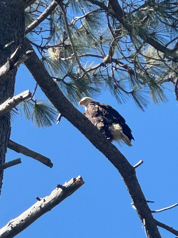
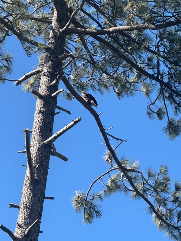
 I stopped on the trail looking for a geocache and I heard this screeching. Looked all over for some kind of creature. Then when I was signing the log, I heard it again - like right in front of me. That’s when I saw the Bald Eagle. Stayed there for a long time, the Eagle giving me the eagle eye. Finally it took off to another tree top 🦅 N 32 59.192 W 116 34.229
Wednesday, May 14, 2025
Southern Bald Eagle

Friday, May 9, 2025
Badger Creek Dispersed Camping
050625 Badger Creek Dispersed Camping - Marble Canyon, Grand Canyon National Park. 36°46'35.2"N 111°39'33.0"W
I left the Flagstaff mountains, heading north towards Page AZ. My first stop was Valentine's Bridge at Tanner's Crossing, now called Cameron. Over a gorge of the Little Colorado on the edge of Navajo and Hopi country a sway-back, one-track suspension bridge was erected in 1911.


2. What do you think horseshoe bend will look like 5 million years from now?All things equal, the river will go dry. But 5million years any number of geological events could take place. 3. How many millions of years did it take sand dunes to become petrified by the calcite, retaining their beautiful sloping dune shapes? 20 million or so <-- I googled this
4. The different colors, except for white, are caused by the presence of varying mixtures and amounts of what filling the pore space within the quartz sand comprising the Navajo Sandstone. Minerals that are impacted by the environment such as iron particles
5. Describe in your own words what you are seeing and experiencing as you visit Horseshoe Bend. Wow there was a lot of people but glad to see high interest. What I am thinking is this is a standard piece of science on a really large scale. Next I headed back south to the Historic Navajo Bridge, which was the first bridge over the Colorado River for 600 miles. When the historic Navajo Bridge opened on January 12, 1929, Flagstaff's newspaper, the Coconino Sun, called it "the biggest news in southwest history." (https://www.geocaching.com/geocache/GC8209_historic-navajo-bridge)
 I took a nice stroll across the bridge enjoying the views. I really like visiting historic bridges and taking photos of the engineering.
Arch 616', Total length 834' Height 467'


Now that I have entered the Marble Canyon area, it's time to find a place to set up camp. I used a app call Campendium to find Badger Creek Dispersed Camping BLM (Bureau of Land Management) public land. This particular spot started with a rough entrance off hwy 89A, but the van handled it very well, but a few things fell off the shelf. I went in about a mile, well away from the fifth wheel I passed and pull off into a camp site - right into some loose sand. 
With tires spinning I got popped back on the rocky road. So I got out and found some hard packed dirt, parked and got the Jagrundi out and peddled farther in to see how the road is. Although it the road had some ruts and exposed boulders, it looked passable. In fact the next occupied campsite was a low clearance minivan. But I kept riding all the way to the canyon edge, 2 miles from the main road. The last campsite had room for a large group and it lies right on the canyon edge. That's when it started raining. By the time I got back to the van I was all wet. Reloaded the bike and waiting for the rain the stop. Pretty soon I made my way to a nice campsite a little farther in. It kept raining off and on. I could see the rain clouds coming in over the cliffs. I counted 4 other campers during my bike ride, but as sunset neared four more came up the road, 2 vans, a pickup and a 4runner.


With tires spinning I got popped back on the rocky road. So I got out and found some hard packed dirt, parked and got the Jagrundi out and peddled farther in to see how the road is. Although it the road had some ruts and exposed boulders, it looked passable. In fact the next occupied campsite was a low clearance minivan. But I kept riding all the way to


There was plenty of room between campers.
The clouds stayed all night, so there was no star gazing. 

I had a good meal and read my book.
The wind picked up so I took my awning down.
No rain in the morning and it was an easy 65°
I really wanted to stay another day, but I had a Van upgrade appointment the next day so I had to make my way home. 
Before I left the area, I went on a long bike ride hunting a couple geocaches on another jeep trail that ended with a 450' drop to the Colorado river. After that I stopped at the Cliff Dwellers stone house for a Virtual Cache. After posting my log, I took off back the way I came and visited Lees Ferry, Glen Canyon, $30 entrance fee, this is where they start a lot of the river rafting. Beautiful cliff views and I visited the old dwellings of the Mormon settlers. I took my time, parked by the river and had some lunch. Eventually, I made my way back through the Navajo settlements, Flagstaff, Sedona and into the Phoenix valley, getting home about 1900. Arizona has such a diverse land scape reachable within hours. Desert, mountains, cliffs and cactus forests. Here is the link to my iCloud album for this trip: Badger Creek Dispersed camping

Before I left the area, I went on a long bike ride hunting a couple geocaches on another jeep trail that ended with a 450' drop to the Colorado river. After that I stopped at the Cliff Dwellers stone house for a Virtual Cache. After posting my log, I took off back the way I came and visited Lees Ferry, Glen Canyon, $30 entrance fee, this is where they start a lot of the river rafting. Beautiful cliff views and I visited the old dwellings of the Mormon settlers. I took my time, parked by the river and had some lunch. Eventually, I made my way back through the Navajo settlements, Flagstaff, Sedona and into the Phoenix valley, getting home about 1900. Arizona has such a diverse land scape reachable within hours. Desert, mountains, cliffs and cactus forests. Here is the link to my iCloud album for this trip: Badger Creek Dispersed camping
Thursday, May 8, 2025
Bonito Lava Flow and Campground
050525 Bonito Campground Coconino National Forest 35.369639, -111.540498

The weather was still cloudy and rainy when I checked in at the Bonito Campground. Elevation 6926' There were about a dozen campers, but everyone seemed to stay in their rigs avoiding the rain. I didn't even set up my table and chair outside, no reason getting everything all wet.


Here is a link to my iCloud photos.
Tuesday, May 6, 2025
Lyman Lake State Park
0425-26 25 34°21'23.5"N 109°22'45.3"W
Way off the beaten path, not very far from the state line, Lyman Lake sits half way between St. John and Springfield. The lake was low and muddy looking. I didn't anyone fishing and the only water activity were a brief paddle boarding. 
The space I had had a real nice shade tree, up on the the hill with a good view of the lake. No geocaching on state parks, but I did get in some real nice hiking and rode Jagurandi along the beach.

The space I had had a real nice shade tree, up on the the hill with a good view of the lake. No geocaching on state parks, but I did get in some real nice hiking and rode Jagurandi along the beach.
I rode out to Rattlesnake Point Pueblo ruin, built between 1325 and1390, occupied by the ancestors of modern Pueblo Indian groups. The pueblo overlooked the Little Colorado River.

I really enjoyed seeing the Indian history and imagined how it would be to live as they did.
Wednesday, April 23, 2025
Wild West RV Ranch - Harvest Host
042125 Wild West RV Ranch Maricopa, AZ
I only wanted a place for one night. I left home and did some geocaching in the area. This is a Harvest Host location. A membership program that is kind of like Airbnb, where the membership includes one night stay and they offer things to purchase. Farms, Wineries and just peoples property. The protocol is to purchase something.

I thought this was just a farm, but it turned out to be a long term RV park. They had electrical, water and sewage hook ups for additional $.
There was no "Wild West" at all. Just a office/store where you can buy convenience store items. I purchased electrical hook up $30. I was the only camper in the camper area, so it wasn't bad, but not really camping. Other Photos

I found a cool Letterbox cache and some other traditional caches before checking in.
I need to be home this week so I can put out my recycling and compost for pickup. But I did I booked a site at Lyman Lake State Park for Friday and Saturday 😎
Friday, April 18, 2025
Mogollon Rim Campground
041525 - 041725 Rim Campground 34.3064, -110.9071

The Rim Road is narrow, but well maintained with a lot of logging industry in evidence.
At 1330 It was raining a little when I turned off to look for a place to camp. I got out and walked to the edge of the ridge to take in the beautiful views. There were only two other campers, a 5th wheel by the entrance and off in the distance I could make out a 4x4 with a teardrop trailer, By the time I got parked and set up, the rain completely stopped and the sun shown through partly cloudy skies. Taking advantage of this wonderful weather, I jumped on Jaguarundi to go geocaching.


The second day was filled with a combination of biking and hiking. The geocaches I found were traditional regular sized deep in the woods, the way it was ment to be. Later on I expected the icy wind 🌬to die down like it did the day before, but it never did and the temperature kept dropping. I found myself hunkering down inside the van. The Windy.com had the wind at 15-20 knots with gusts up to 30. Needless to say, I did not put the Moon Shade back up, and could not keep the camp stove lit outside. I had planned to make a fire, but it was just too windy. I am so glad I packed my thermal pajamas, thanks BRH. 


The next day was like the second day, 45°F with wind chill 34°. After breakfast, I packed up to go do some road caching. After finding a couple I found myself back down the Rim road, so I just headed home.
Here's a link to all my photos
Monday, April 14, 2025
Alamo Lake State Park

Only about 2 1/2 hours west of Sun City, this is a popular weekend fishing spot and OHV sports. But during the week, there was very few OHV, most of the campers were there for the smallmouth bass. I took my time and arrived at about 1500. I reserved space B33 and started my setup. There was no service, but I remember reading that the reviewers showed cell coverage. I jumped on my ebike and rode around all the other camping areas. I saw wild Burros on my trip over to the C,D & E. I also discovered good 5G in Campground E, so I returned to the van, packed up and moved to E3.

My new campsite was on the edge of the culvert where the wild Burros wandered down towards the lake shore. At night, I had an amazing view of the night sky and the full moon. In the morning, I headed out on the ebike and made my way to the office. The volunteers were very helpful, so I purchased a t-shirt and park stickers. I proceed to go after the remaining geocaches in the area, ending with a nice hike up above the lake. Did some more exploring on the bike.

Link to photos
The next morning I tried my luck at fishing, but I really was not into it. I kept thinking I hope I can release it if I catch one, because I really don’t want to deal with it. I ended up walking more than fishing, enjoying the cool wind off the water. After lunch, I rode around the park some more, then took a refreshing shower using the van rear faucet.

Link to photos
Wednesday, April 9, 2025
FR 525 Cockcomb Camp area, Coconino National Forest, near Sedona AZ.
040235
Coconino National Forest. I made my way out of Cottonwood on highway 86A then left on to Forest Road
525. As soon as I headed up the road I could start to see the red rock canyon
sides and snow capped mountains. I am southwest of Sedona, only about 20 miles
further on 86A. Even though there is a line of caches all the way up the road,
my focus is finding a place to camp. The Forest Service has designated the
dispersed camping areas, there are signs making it clear where and where not to
camp. The first one called Surprised was about ½ full with big rigs. Next off to
the left was the Windmill, a small camping area and looked crowded.
 I have heard about this area and many reviews about how bad the road and how
crowded it can get. I started to get concerned, but the road was excellent so
far, yes it was bumpy, but not bad. After a while, about 4 miles in, I turned
into Cockscomb camping area and found a spot with a view between a school bus
and a German Utility Vehicle. I considered going farther and looking at Greasy
Spoon and Nolan, but as I got out to look at the space I was greeted by a
neighbor from Germany and he was very welcoming and said that they shipped the
rig from Germany, landing in Nova Scotia.
I have heard about this area and many reviews about how bad the road and how
crowded it can get. I started to get concerned, but the road was excellent so
far, yes it was bumpy, but not bad. After a while, about 4 miles in, I turned
into Cockscomb camping area and found a spot with a view between a school bus
and a German Utility Vehicle. I considered going farther and looking at Greasy
Spoon and Nolan, but as I got out to look at the space I was greeted by a
neighbor from Germany and he was very welcoming and said that they shipped the
rig from Germany, landing in Nova Scotia.
 They made their way to Arizona hoping to get out of the cold. He laughed and
said it’s cold here too. I asked if this is a good spot to camp for a couple
days, He said yes, but there will be another vehicle with them later on. So I
decided to stay there. After leveling and blocking my little van, I opened the
side door and sat, taking in the view. Also the dark clouds that were moving
over the distant ridge. Sure enough it started to rain.
They made their way to Arizona hoping to get out of the cold. He laughed and
said it’s cold here too. I asked if this is a good spot to camp for a couple
days, He said yes, but there will be another vehicle with them later on. So I
decided to stay there. After leveling and blocking my little van, I opened the
side door and sat, taking in the view. Also the dark clouds that were moving
over the distant ridge. Sure enough it started to rain.
About 1600, the weather cleared. I put out the solar panels and unloaded the Jaguarundi. I proceeded to ride up the road for about 3 miles, passing the final 2 camping areas. The rain came back but not hard, so I grabbed a few caches.
 Soon, I was getting pretty cold, so I headed back to camp. Once in the Van with
dry clothes, dinner was a salad and one of the ready to eat meals that I heated
up in my little red pan. After dark it really starts to get cold. I figure that
I’ll just layer up, no way I’m using that electric heater and drain my
batteries. Fully jammyed, I lay under a sheet and blanket, it was cold. I wished
I would have brought more blankets, then I realized I did bring my REI sleeping
bag! I slept like a “Happy Camper”
Soon, I was getting pretty cold, so I headed back to camp. Once in the Van with
dry clothes, dinner was a salad and one of the ready to eat meals that I heated
up in my little red pan. After dark it really starts to get cold. I figure that
I’ll just layer up, no way I’m using that electric heater and drain my
batteries. Fully jammyed, I lay under a sheet and blanket, it was cold. I wished
I would have brought more blankets, then I realized I did bring my REI sleeping
bag! I slept like a “Happy Camper”
040325 The next day it rained all morning. It Even snowed a little. I stayed inside and had a hearty breakfast and more coffee. But it cleared a little, so I jumped on the bike. It rained, it snowed, and it was kind of sunny at times. Conditions were fine for geocaching, but the wind while riding was cold. But I did go farther up the road.
Later on I decided to hike and leave the bike in the garage. I found myself on top of a nearby hill with a very nice view of the distant red rock mountain sides and Cockscomb camping area.
040425 Friday was still cold, but clear. I rode all the way the the cliffs, well as far as I could ride. Up a really rocky jeep road that ended with the view of the red rock canyons. Majestic!
Of course there was a cache there, but many muggles in these tour jeeps. I sure I got some strange looks, old guy with an ebike walking around a tree like he needs to take a piss, I say let them think what they will. At least I'm getting a smiley! I took my time and took a lot of photos.
By noon, I was back at the Van packing up for home. I decided to drive by next week's camping spot on the way home, glad I did. Hilltop campground in Prescott National Forest, there is still snow on the ground but it would not stop me. The site I reserved was a tent sight, the parking was on a steep hill. No way I would be able to level the van. Besides, this is Arizona, I want to find a place a little warmer. I got home about 5pm and started planning my next trip.


About 1600, the weather cleared. I put out the solar panels and unloaded the Jaguarundi. I proceeded to ride up the road for about 3 miles, passing the final 2 camping areas. The rain came back but not hard, so I grabbed a few caches.

040325 The next day it rained all morning. It Even snowed a little. I stayed inside and had a hearty breakfast and more coffee. But it cleared a little, so I jumped on the bike. It rained, it snowed, and it was kind of sunny at times. Conditions were fine for geocaching, but the wind while riding was cold. But I did go farther up the road.

Later on I decided to hike and leave the bike in the garage. I found myself on top of a nearby hill with a very nice view of the distant red rock mountain sides and Cockscomb camping area.

040425 Friday was still cold, but clear. I rode all the way the the cliffs, well as far as I could ride. Up a really rocky jeep road that ended with the view of the red rock canyons. Majestic!

Of course there was a cache there, but many muggles in these tour jeeps. I sure I got some strange looks, old guy with an ebike walking around a tree like he needs to take a piss, I say let them think what they will. At least I'm getting a smiley! I took my time and took a lot of photos.

By noon, I was back at the Van packing up for home. I decided to drive by next week's camping spot on the way home, glad I did. Hilltop campground in Prescott National Forest, there is still snow on the ground but it would not stop me. The site I reserved was a tent sight, the parking was on a steep hill. No way I would be able to level the van. Besides, this is Arizona, I want to find a place a little warmer. I got home about 5pm and started planning my next trip.
Monday, April 7, 2025
Dead Horse Ranch State Park Campground
040125 Dead Horse Ranch State Park Campground is my RV park with hookups maiden voyage. I wanted to experience the whole connecting electrical and water and most importantly dumping the gray tank. I arrived just after check in time and had no problem finding my spot. Backed in and leveled, connected the 30amp and city water. The 30 amp charges the batteries as you use it. The inverter detects the connection and the juice is routed to the AC service. Easy peasy.
  What I didn't realize is the city water doesn't fill the tank. THe flow is diverted to the sink. The only way to get water in the tank is through the “gravity fill”. I noticed right away that everyone else had an inline filter, which I didn’t have. I was able to figure out these connections no problem. Soon after getting connected it started raining. I made some coffee and hunkered down and let it rain.

At about 1600 the sun came out, so I went for a walk on the nearby trail and found two geocaches, the second one has a view. By the time I got back it was time to make dinner and get settled for the night.
 Next day I got up early and took a shower then cooked breakfast. Watched some Youtube videos and was ready to leave by 10am. On the way out, I stopped at the dump station. Pulled in behind a fifth wheel and was able to get coached as they dumped. I was able to drain the gray tank without incident. The only thing I didn’t have was a pair of gloves. Only took a few minutes, pulled out and went into the gift shop and bought some stickers, then headed for FR 525 in the Coconino National Forest, near Sedona.


At about 1600 the sun came out, so I went for a walk on the nearby trail and found two geocaches, the second one has a view. By the time I got back it was time to make dinner and get settled for the night.

👀 Photos 👀
Sunday, April 6, 2025
Tuzigoot National Monument


Saturday, April 5, 2025
Keel Boat Basic 101 - Lake Pleasant AZ
03/29 and 30/2005 Lake Pleasant
There were only 3 people in the class, myself and a couple also from Sun City Wendy and Mark. Starting at 8am, we went to the classroom for an hour, then we went onboard a 22' Catalina. Captain Clint took us out teaching us all the way on the written and unwritten rules of entering and leaving a no wake zone. We rounded the final buoys and entered the lake proper. Mark and I raised the mainsail and unfurled the jib, then the next thing I knew Captain put me at the tiller and I was sailing!
 We covered tacks and Jibe and all the points of sail, but mostly beam reach, close reach and close hauled. Captain Clint does not like down wind sailing. We took turns at the tiller and practiced tacking and working as a team. Probably had only 10 knots of wind, mostly from the south. But if you got the right balance of sail trim and heel, we could get moving about 6 or 7 knots. We learned that if the boat is heel a lot, which is uncomfortable, it is inefficient and will slow and stall. If there is no heel at all you are pretty much sitting still. As we practiced the points of sail, we learned to feel the boat and the sails getting in the right trim and moving smartly through the water. I was pretty nervous because I completely forgot my waterproof sound processor cover. I soon forgot all about it once we got going. We came in about 2pm and Captain Clint said be back here tomorrow at 8am, the wind will determine if we go out or take the written test.
The next day the wind was predicted to come up later in the morning, so we manned the classroom for the 100 question multi choice test. I missed 4 and only because I was not paying attention to stand off or give way. Anyway it was a passing score! Woohoo! By the time we got in the boat all the pressure was off. We each took turns leaving the dock and redocking, while Captain CLint told sea stories. I was last and it took me two attempts because I was listening to sea stories. After my successful docking, I took her all the way out, hoisted the main and unfurled to jib, but the wind was light from the south, so we crept out into the middle of the lake motor sailing. By about 1115, the wind came up enough to practice Man Overboard maneuvers.
The wind increased and Mark and I did circles around the island hazard completing all the points of sail, then Wendy took us in. Because we were going to a different spot on the dock, Captain Clint took her in by sail "show off" and we tied her up. Back in the classroom, we received our logbooks with Captain's Clint's signature. We will receive the official stamp in the mail.
 I can't say the class was hard, it was pretty easy, but I learned a lot, mostly to just let the conditions move the boat, just guide it where and how you need.

The next day the wind was predicted to come up later in the morning, so we manned the classroom for the 100 question multi choice test. I missed 4 and only because I was not paying attention to stand off or give way. Anyway it was a passing score! Woohoo! By the time we got in the boat all the pressure was off. We each took turns leaving the dock and redocking, while Captain CLint told sea stories. I was last and it took me two attempts because I was listening to sea stories. After my successful docking, I took her all the way out, hoisted the main and unfurled to jib, but the wind was light from the south, so we crept out into the middle of the lake motor sailing. By about 1115, the wind came up enough to practice Man Overboard maneuvers.
The wind increased and Mark and I did circles around the island hazard completing all the points of sail, then Wendy took us in. Because we were going to a different spot on the dock, Captain Clint took her in by sail "show off" and we tied her up. Back in the classroom, we received our logbooks with Captain's Clint's signature. We will receive the official stamp in the mail.


Subscribe to:
Posts (Atom)